
Fichiér:Netherlands-CIA WFB Map-10-10-10.png
Gins de rèsolucion ples hiôta disponibla.
Netherlands-CIA_WFB_Map-10-10-10.png (330 × 353 pixèls, talye du fichiér : 68 Kio, tipo MIME : image/png)
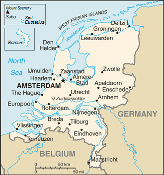
| Dèscripcion | Map of the Netherlands |
| Dâta | (UTC) |
| Sôrsa | |
| Ôtor |
|
| Cette image a été retouchée, ce qui signifie qu'elle a été modifiée par ordinateur et est différente de l'image d'origine. L'image d'origine se trouve ici : Netherlands-CIA WFB Map.png:
|
Cette image est dans le domaine public parce que son contenu provient du World Factbook, édité par la Central Intelligence Agency des États-Unis d’Amérique.
|
 |
Jornal des tèlèchargements d’origina
This image is a derivative work of the following images:
- File:Netherlands-CIA_WFB_Map.png licensed with PD-USGov-CIA-WF
Téléversé avec derivativeFX
Historico du fichiér
Cllicar dessus na dâta et hora por vêre lo fichiér coment il ére que.
| Dâta et hora | Miniatura | Dimensions | Utilisator | Comentèro | |
|---|---|---|---|---|---|
| d’ora | 14 septembro 2019 a 16:17 | | 330 × 353 (68 Kio) | Thayts | Borkum to Germany |
| 7 dècembro 2010 a 11:40 |  | 330 × 353 (33 Kio) | LennartBolks~commonswiki | {{Information |Description=Map of the Netherlands |Source=*File:Netherlands-CIA_WFB_Map.png |Date=2010-12-07 11:39 (UTC) |Author=*File:Netherlands-CIA_WFB_Map.png: CIA *derivative work: ~~~ |Permission= |other_versions= }} {{RetouchedPicture| |
Usâjo du fichiér
Gins de pâge emplèye cél fichiér.
Usâjo gllobâl du fichiér
Cetos ôtros vouiquis emplèyont cél fichiér :
- Usâjo dessus dsb.wikipedia.org
- Usâjo dessus en.wikipedia.org
- Usâjo dessus en.wikiversity.org
- Usâjo dessus gom.wikipedia.org
- Usâjo dessus incubator.wikimedia.org
- Usâjo dessus ja.wikipedia.org
- Usâjo dessus lt.wiktionary.org
- Usâjo dessus ms.wikipedia.org
- Usâjo dessus mt.wikipedia.org
- Usâjo dessus my.wikipedia.org
- Usâjo dessus pl.wikipedia.org
- Usâjo dessus pl.wikivoyage.org
- Usâjo dessus ps.wikipedia.org
- Usâjo dessus pt.wikipedia.org
- Usâjo dessus ro.wikipedia.org
- Usâjo dessus simple.wikipedia.org
- Usâjo dessus sq.wikipedia.org
- Usâjo dessus szl.wikipedia.org
- Usâjo dessus to.wikipedia.org
- Usâjo dessus www.wikidata.org