
Fichiér:Map German SpeakingWorld.png

Talye de cél apèrçu : 800 × 370 pixèls. Ôtres rèsolucions : 320 × 148 pixèls | 640 × 296 pixèls | 1 357 × 628 pixèls.
Fichiér d’origina (1 357 × 628 pixèls, talye du fichiér : 36 Kio, tipo MIME : image/png)

|
Une version vectorielle de cette image existe, dans le format « SVG ». Si elle n’est pas inférieure, elle devrait être utilisée à la place de la présente version pour des affichages en plus grandes dimensions ou nécessitant une meilleure résolution.
File:Map German SpeakingWorld.png → File:Legal statuses of German in the world.svg
Pour plus d’informations sur les images vectorielles, consultez la page de transition de Commons vers le format SVG. Voir aussi les informations à propos de la manière dont le logiciel MediaWiki gère les images au format SVG. |
 |
| Dèscripcion |
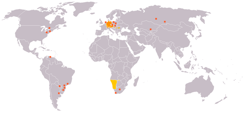
English: Legend:
Deutsch: Legende:
Français : Carte du monde où on parle l'allemand.
עברית:
Italiano: Legenda:
Nederlands: Beschrijving:
Svenska: Beskrivning:
|
||||||||
| Sôrsa | en:Image:Map_German_World.png | ||||||||
| Ôtor | en:User:Ilario. | ||||||||
| Pèrmission (Reusâjo de cél fichiér) |
Mè, lo titulèro du drêt d’ôtor de ceta ôvra, la publeyo avouéc cen desot cetes licences :
Vos pouede chouèsir la licence que vos voléd. |
||||||||
| Ôtres vèrsions | File is obsolete! Use File:Legal statuses of German in the world.svg instead. |

Historico du fichiér
Cllicar dessus na dâta et hora por vêre lo fichiér coment il ére que.
| Dâta et hora | Miniatura | Dimensions | Utilisator | Comentèro | |
|---|---|---|---|---|---|
| d’ora | 18 julyèt 2020 a 20:35 | | 1 357 × 628 (36 Kio) | Maphobbyist | South Sudan and Montenegro borders |
| 11 novembro 2007 a 09:14 |  | 1 357 × 628 (46 Kio) | Domaleixo | ||
| 27 julyèt 2006 a 18:28 |  | 1 357 × 628 (25 Kio) | Cwlq~commonswiki | ||
| 28 jouin 2006 a 06:18 |  | 1 357 × 628 (37 Kio) | Highpriority | {{Information |Description=en: Legend: *Orange: native language *Gold: Secondary language or non-official. *Red-orange square: German minorities de: Legende: *dunkles Orange: Amtssprache/Muttersprache *helles Orange: Zweitsprache oder nicht offiziel |
Usâjo du fichiér
Gins de pâge emplèye cél fichiér.
Usâjo gllobâl du fichiér
Cetos ôtros vouiquis emplèyont cél fichiér :
- Usâjo dessus de.wikipedia.org
- Usâjo dessus fr.wikipedia.org
- Usâjo dessus incubator.wikimedia.org