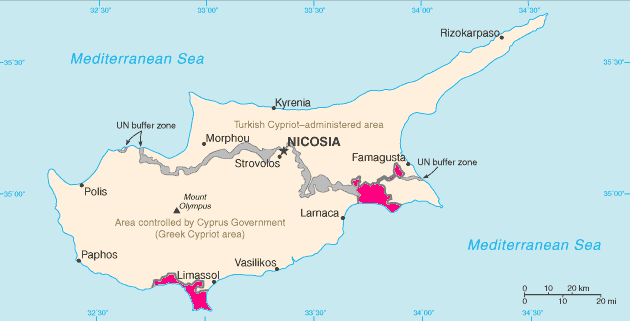
Fichiér:Cyprus SBAsInRed.png
Apparence
Cyprus_SBAsInRed.png (630 × 321 pixèls, talye du fichiér : 9 Kio, tipo MIME : image/png)
Historico du fichiér
Cllicar dessus na dâta et hora por vêre lo fichiér coment il ére a cél moment.
| Dâta et hora | Miniatura | Dimensions | Utilisator | Comentèro | |
|---|---|---|---|---|---|
| d’ora | 14 mê 2012 a 01:01 |  | 630 × 321 (9 Kio) | Mattbuck | Reverted to version as of 10:19, 6 May 2012 |
| 6 mê 2012 a 14:39 |  | 1 148 × 589 (30 Kio) | An678ko | everted to version as of 13:00, 6 May 2012; identical to File:Akrotiri and Dhekelia.png Pleasе, leave this map! stop modify and update them! Wikipedia is not fun! I added a beautiful card with a modern design! You also try to keep a card which 7 year... | |
| 6 mê 2012 a 10:19 |  | 630 × 321 (9 Kio) | NordNordWest | Reverted to version as of 19:00, 30 March 2012; identical to File:Akrotiri and Dhekelia.png | |
| 6 mê 2012 a 01:32 |  | 1 148 × 589 (30 Kio) | An678ko | Was modified the Turkish-Cypriot border (May 1, 2012), added new Turkish village | |
| 30 mârs 2012 a 19:00 |  | 630 × 321 (9 Kio) | Trijnstel | Reverted to version as of 19:06, 3 June 2007 - identical to File:Akrotiri and Dhekelia.png | |
| 27 mârs 2012 a 06:57 |  | 1 148 × 589 (30 Kio) | An678ko | best quality | |
| 3 jouin 2007 a 19:06 |  | 630 × 321 (9 Kio) | Tene~commonswiki | Optimised (0;r) | |
| 26 oût 2006 a 21:34 |  | 630 × 321 (27 Kio) | Hoshie | The map has been updated to show the color of the SBAs in the traditional pink color. | |
| 9 oût 2005 a 21:55 |  | 630 × 321 (20 Kio) | Nicke L | From en: Map of Cyprus with WSBA and ESBA in red. The map is adapted from the [http://www.cia.gov/cia/publications/factbook/maps/cy-map.gif CIA World Factbook] map. {{PD-USGov-CIA-WF}} Uploaded 14:03, 1 May 2005 by Hoshie [[Category:CIA factbook m |
Usâjo du fichiér
Ceta pâge emplèye cél fichiér :
Usâjo gllobâl du fichiér
Cetos ôtros vouiquis emplèyont cél fichiér :
- Usâjo dessus an.wikipedia.org
- Usâjo dessus ar.wikipedia.org
- Usâjo dessus ast.wikipedia.org
- Usâjo dessus as.wikipedia.org
- Usâjo dessus av.wikipedia.org
- Usâjo dessus az.wikipedia.org
- Usâjo dessus ban.wikipedia.org
- Usâjo dessus be-tarask.wikipedia.org
- Usâjo dessus be.wikipedia.org
- Usâjo dessus bg.wikipedia.org
- Usâjo dessus bh.wikipedia.org
- Usâjo dessus bn.wikipedia.org
- Usâjo dessus br.wikipedia.org
- Usâjo dessus bs.wikipedia.org
- Usâjo dessus ca.wikipedia.org
- Usâjo dessus ce.wikipedia.org
- Usâjo dessus cs.wikipedia.org
- Usâjo dessus da.wikipedia.org
- Usâjo dessus de.wikipedia.org
- Usâjo dessus el.wikipedia.org
- Usâjo dessus en.wikipedia.org
- Akrotiri and Dhekelia
- British Forces Cyprus
- User:TheGrappler/Europe directory
- Sovereign Base Areas Customs and Immigration
- User:The Transhumanist/Sandbox19
- List of sovereign states and dependent territories in Eurasia
- Wikipedia:Graphics Lab/Map workshop/Archive/Apr 2011
- User:Seric2/British Cyprus
- User:Foghe/Akrotiri
- Usâjo dessus eo.wikipedia.org
- Usâjo dessus es.wikipedia.org
- Usâjo dessus es.wikivoyage.org
- Usâjo dessus et.wikipedia.org
- Usâjo dessus eu.wikipedia.org
- Usâjo dessus fa.wikipedia.org
Vêre més d’usâjo gllobâl de cél fichiér.


